Wednesday, February 16, 2005


Trinidad CA; BK photo Posted by Hello

Incredibly ancient but still changing:

by Bill Kowinski

The earth is alive. For most places, that might be a cuddly kind of metaphor but on the North Coast, it describes the ground beneath our feet. The land itself is changing more actively than in most places: rising, falling, moving. The North Coast is still shaping itself.

About a month before the Asian earthquake and tsunami put geology on the world news map, I thought I'd start my exploration of the physical North Coast from the ground up, so I visited Susan Cashman, chair of the Humboldt State University Geology department.

Geology is down in the basement of Founder's Hall, and when I mentioned that this seemed fitting since it is the study of what supports us from underneath, Sue told me there was a more prosaic reason. Most geology departments have historically been on the ground floor, she said, probably because of all the heavy rocks they use for study and exhibit. Too heavy to carry up a lot of stairs, and maybe too much of a strain on the floors.

Like me, Sue Cashman is from the eastern half of the continent where the landscape is generally a more settled thing. It changes a little due to erosion, but the last major cause of larger alterations were Ice Age glaciers, some 60 thousand to perhaps 10 thousand years ago in places.

"I grew up in New England and started being a geologist as an undergrad there, so I know those old mountains some," Sue said. "The setting looks similar to this, but that area ceased to be an active plate boundary hundreds of millions of years ago, and it's now incorporated in the middle of the North American plate, which extends from right here in Humboldt County all the way to the center of the Atlantic Ocean."

So today the northeast is "compressing or deforming internally now, but it's being affected more by surface processes that are sculpting it, like river erosion, whereas here in Humboldt county, we certainly have the erosion, but the landscape is still actively forming because we're at a boundary between plates that's causing things to move up and down."

"And there's the action of the ocean," I suggested.

"There's the action of the ocean, and the rainfall destabilizing landscapes, so we have a lot of landslides and rapid erosion ---it's a great place to be a geologist because all kinds of things are happening."

text continues after illustration

from EnchantedLearning.com Posted by Hello
People always wondered about the earth beneath their feet, of course. Indigenous cultures had creation stories that often centered on the mountains or gorges, lakes or river valleys where they lived.

But even though geology studies some of the oldest aspects of the earth, as a science it is quite young. It didn't really get started until the early 19th century, as new industrial technologies exposed more of the earth to inquiring minds when it was dug up for coal mines, canals and roads. William Smith, who produced one of the first studies of rock strata and their relationship to fossils, was a surveyor and canal builder in England.

It was early geologists, like James Hutton, George Poulett Scrope and Charles Lyell, who first established that the earth is very, very old. (Lyell's three volume Principles of Geology was among Charles Darwin's favorite reading during his voyage on the Beagle, when he started developing his theory of evolution.)

That these basic forces of earthquake and volcano, wind and water were responsible for the composition and contours of the earth, was understood and calibrated in meticulous detail and with mystifying nomenclature for many years. But an underlying cause wasn't established until the 1960s and 70s.

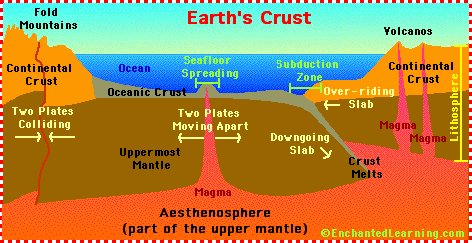
Then geologists began to understand that there are about a dozen huge plates, relatively thin, rigid slices composed of the earth's crust and the upper part of the mantle (the lithosphere), riding the partially molten lower mantle (the aesthenosphere), under all the land and water surface on the planet. These plates have been moving slowly but inexorably for millennia, and they are still moving at a rate of from one to six inches a year. Earthquakes and volcanoes occur in a zone where two or more plates meet.

In the northeastern U.S., the landscape was created by seismic events millennia ago when plate boundaries were located there. Then came the glaciers to further shape the land. But here on the North Coast, "There weren't glaciers that covered this area," Sue Cashman said. "On the West Coast the ice only came down as far south as Olympia, Washington. The Puget lowland area, Seattle-Tacoma, were under ice, but south of Olympia there wasn't a solid icesheet. Only the mountaintops south of Olympia were affected by the smaller alpine glaciers."

But also in contrast to the northeast, this area has several plates still in action, and various kinds of plate boundaries. "There's a big plate boundary here, of the North American plate, the Pacific plate that goes all the way to Japan and New Zealand, and a there's a separate piece of ocean floor that goes from here to British Columbia that's thrusting, pushing underneath and subducting North America." This third plate is called the Gorda plate, and its extension north of here is the Juan De Fuca plate. "Right at Petrolia there's a new junction of these three plates, with a boundary that goes offshore, along the Mendicino fault zone. This is one of maybe a dozen triple junctions in the world."

It makes this one of the most active earthquake zones on the planet. "These three plates are moving in different directions. You take this and wrap it on a sphere and it gets to be really complicated. We have the upper edge of the North American plate bending and faulting and fracturing. Some of the earthquakes we feel are actually occurring below us, from that piece that is pushing underneath and breaking up."

Earthquakes can change the landscape quickly and dramatically, but other slower movement creates more gradual change. These alterations may be hard to see, but they're happening, right alongside older evidences of prodigious structures created and shaped over eons. The landscape is a kind of living museum of the earth's restlessness.

Trinidad Beach, Photo: BK Posted by Hello
Some places show off this history especially well. "Trinidad is a remarkable place geologically," Sue remarked. "The bedrock that underlies the region of Trinidad and the eastern part of McKinleyville, and Blue Lake to Willow Creek, consists of what's called the Franciscan Formation. Its name comes from the Bay Area, and it describes a very mixed assemblage of rocks, including those that formed in the deep ocean, the shallow ocean margin, volcanic rocks we think formed on the sea floor, rocks that formed deep in the earth's crust---all mixed together."

Many of the large offshore rocks and seastacks at Trinidad are examples of Franciscan Formation, and they are hundreds of millions of years old. Some may have been pushed up from the ocean floor and have been standing where they stand today for tens of thousands of years.

"This very mixed sandwich of rock we think were gradually accreted over long periods of time at the continental margin, where the oceanic crust is thrusting under the edge of the continent." But there's also part of Trinidad that's considerably younger.

"Marine terraces were formed by the ocean, both beveling off a flat surface because of wave action, then depositing sand on top of it. As the crust is being worked in an active tectonic setting, these old wave-cut platforms are raised upward. Basically these are old beaches that have been moved above sea level---and the town of Trinidad is sitting on one of them." So while some of the offshore rocks at Trinidad are 70 to 150 million years old, the flat surface where the town of Trinidad sits is about 60 thousand years old. "That's two different time frames contributing to Trinidad's interesting geologic history."

North Coast Geology Links

Humboldt area geology
http://ebeltz.net/fieldtrips/humgeol.html

U.S. Geological Survey maps of North Coast
http://geo-nsdi.er.usgs.gov/metadata/map-mf/2336/metadata.html

HSU Geology Department
http://www.humboldt.edu/~geol/

College of the Redwoods Geology Department
http://www.redwoods.cc.ca.us/Departments/Geology/

suggestions for more? Use the comments...