Showing posts with label landscapes. Show all posts

Monday, March 14, 2005


Arcatan Sunset photo: BK  Posted by Hello

Monday, February 21, 2005


near Mad River beach photo by BK Posted by Hello

Wednesday, February 16, 2005


Trinidad CA; BK photo Posted by Hello

Incredibly ancient but still changing:

by Bill Kowinski

The earth is alive. For most places, that might be a cuddly kind of metaphor but on the North Coast, it describes the ground beneath our feet. The land itself is changing more actively than in most places: rising, falling, moving. The North Coast is still shaping itself.

About a month before the Asian earthquake and tsunami put geology on the world news map, I thought I'd start my exploration of the physical North Coast from the ground up, so I visited Susan Cashman, chair of the Humboldt State University Geology department.

Geology is down in the basement of Founder's Hall, and when I mentioned that this seemed fitting since it is the study of what supports us from underneath, Sue told me there was a more prosaic reason. Most geology departments have historically been on the ground floor, she said, probably because of all the heavy rocks they use for study and exhibit. Too heavy to carry up a lot of stairs, and maybe too much of a strain on the floors.

Like me, Sue Cashman is from the eastern half of the continent where the landscape is generally a more settled thing. It changes a little due to erosion, but the last major cause of larger alterations were Ice Age glaciers, some 60 thousand to perhaps 10 thousand years ago in places.

"I grew up in New England and started being a geologist as an undergrad there, so I know those old mountains some," Sue said. "The setting looks similar to this, but that area ceased to be an active plate boundary hundreds of millions of years ago, and it's now incorporated in the middle of the North American plate, which extends from right here in Humboldt County all the way to the center of the Atlantic Ocean."

So today the northeast is "compressing or deforming internally now, but it's being affected more by surface processes that are sculpting it, like river erosion, whereas here in Humboldt county, we certainly have the erosion, but the landscape is still actively forming because we're at a boundary between plates that's causing things to move up and down."

"And there's the action of the ocean," I suggested.

"There's the action of the ocean, and the rainfall destabilizing landscapes, so we have a lot of landslides and rapid erosion ---it's a great place to be a geologist because all kinds of things are happening."

text continues after illustration

from EnchantedLearning.com Posted by Hello
People always wondered about the earth beneath their feet, of course. Indigenous cultures had creation stories that often centered on the mountains or gorges, lakes or river valleys where they lived.

But even though geology studies some of the oldest aspects of the earth, as a science it is quite young. It didn't really get started until the early 19th century, as new industrial technologies exposed more of the earth to inquiring minds when it was dug up for coal mines, canals and roads. William Smith, who produced one of the first studies of rock strata and their relationship to fossils, was a surveyor and canal builder in England.

It was early geologists, like James Hutton, George Poulett Scrope and Charles Lyell, who first established that the earth is very, very old. (Lyell's three volume Principles of Geology was among Charles Darwin's favorite reading during his voyage on the Beagle, when he started developing his theory of evolution.)

That these basic forces of earthquake and volcano, wind and water were responsible for the composition and contours of the earth, was understood and calibrated in meticulous detail and with mystifying nomenclature for many years. But an underlying cause wasn't established until the 1960s and 70s.

Then geologists began to understand that there are about a dozen huge plates, relatively thin, rigid slices composed of the earth's crust and the upper part of the mantle (the lithosphere), riding the partially molten lower mantle (the aesthenosphere), under all the land and water surface on the planet. These plates have been moving slowly but inexorably for millennia, and they are still moving at a rate of from one to six inches a year. Earthquakes and volcanoes occur in a zone where two or more plates meet.

In the northeastern U.S., the landscape was created by seismic events millennia ago when plate boundaries were located there. Then came the glaciers to further shape the land. But here on the North Coast, "There weren't glaciers that covered this area," Sue Cashman said. "On the West Coast the ice only came down as far south as Olympia, Washington. The Puget lowland area, Seattle-Tacoma, were under ice, but south of Olympia there wasn't a solid icesheet. Only the mountaintops south of Olympia were affected by the smaller alpine glaciers."

But also in contrast to the northeast, this area has several plates still in action, and various kinds of plate boundaries. "There's a big plate boundary here, of the North American plate, the Pacific plate that goes all the way to Japan and New Zealand, and a there's a separate piece of ocean floor that goes from here to British Columbia that's thrusting, pushing underneath and subducting North America." This third plate is called the Gorda plate, and its extension north of here is the Juan De Fuca plate. "Right at Petrolia there's a new junction of these three plates, with a boundary that goes offshore, along the Mendicino fault zone. This is one of maybe a dozen triple junctions in the world."

It makes this one of the most active earthquake zones on the planet. "These three plates are moving in different directions. You take this and wrap it on a sphere and it gets to be really complicated. We have the upper edge of the North American plate bending and faulting and fracturing. Some of the earthquakes we feel are actually occurring below us, from that piece that is pushing underneath and breaking up."

Earthquakes can change the landscape quickly and dramatically, but other slower movement creates more gradual change. These alterations may be hard to see, but they're happening, right alongside older evidences of prodigious structures created and shaped over eons. The landscape is a kind of living museum of the earth's restlessness.

Trinidad Beach, Photo: BK Posted by Hello
Some places show off this history especially well. "Trinidad is a remarkable place geologically," Sue remarked. "The bedrock that underlies the region of Trinidad and the eastern part of McKinleyville, and Blue Lake to Willow Creek, consists of what's called the Franciscan Formation. Its name comes from the Bay Area, and it describes a very mixed assemblage of rocks, including those that formed in the deep ocean, the shallow ocean margin, volcanic rocks we think formed on the sea floor, rocks that formed deep in the earth's crust---all mixed together."

Many of the large offshore rocks and seastacks at Trinidad are examples of Franciscan Formation, and they are hundreds of millions of years old. Some may have been pushed up from the ocean floor and have been standing where they stand today for tens of thousands of years.

"This very mixed sandwich of rock we think were gradually accreted over long periods of time at the continental margin, where the oceanic crust is thrusting under the edge of the continent." But there's also part of Trinidad that's considerably younger.

"Marine terraces were formed by the ocean, both beveling off a flat surface because of wave action, then depositing sand on top of it. As the crust is being worked in an active tectonic setting, these old wave-cut platforms are raised upward. Basically these are old beaches that have been moved above sea level---and the town of Trinidad is sitting on one of them." So while some of the offshore rocks at Trinidad are 70 to 150 million years old, the flat surface where the town of Trinidad sits is about 60 thousand years old. "That's two different time frames contributing to Trinidad's interesting geologic history."

North Coast Geology Links

Humboldt area geology
http://ebeltz.net/fieldtrips/humgeol.html

U.S. Geological Survey maps of North Coast
http://geo-nsdi.er.usgs.gov/metadata/map-mf/2336/metadata.html

HSU Geology Department
http://www.humboldt.edu/~geol/

College of the Redwoods Geology Department
http://www.redwoods.cc.ca.us/Departments/Geology/

suggestions for more? Use the comments...

Monday, February 07, 2005


wasn't this supposed to happen in SOUTHERN California? Posted by Hello

Earthquake Country

by Bill Kowinski

"We've had two people die in earthquakes in historic times in Humboldt County. That's since 1850. I've run the hazard models, even with the Cascadia earthquake, the most I can kill is maybe 40. I don't mean to be facetious about that but it turns out it's really hard to kill people in earthquakes in Humboldt county. It's much more dangerous to go driving down the road here. "

It was early fall in 1996, and I was about to get my hair cut at the place I'd been going to for at least five years, just off Forbes Avenue near the University of Pittsburgh in the Oakland section of Pittsburgh, PA. It was an emotional time, since I was giving up my Pittsburgh life and an apartment I loved, moving away from my local friends and favorite places, to a new life on the North Coast of California. So there were crosscurrents of contrary emotions, sad and exciting at the same time.

Sunshine was pouring into the room as I picked up a magazine to read while I waited. It was 
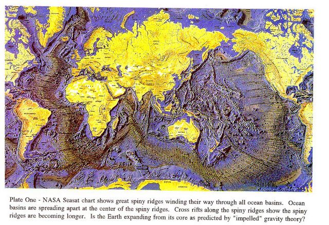
Rolling Stone, and inside was an article concerning the area of California that was more endangered by earthquakes than the more famous vicinity of the fabled San Andreas fault. It turned out to be the North Coast. Exactly where I was going. It was the first inkling I had that I was committing everything to a place expecting a powerful earthquake, and one of the most seismically active landscapes in the world.


One of the people prominently quoted in 
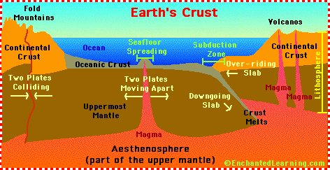
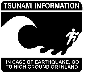
Rolling Stone was named Lori Dengler, in her fourth year or so of teaching at Humboldt State University. Although I haven't seen the article in years, what I most recall is a scene that had Dengler standing near route 101 in Eureka and talking about how after the earthquake the highway and the mall would be swept with a tsunami.

After the recent Community Forum at HSU, prompted by the devastating December 26, 2004 earthquake and tsunamis in the Indian Ocean, I told this story to one of the presenters, geophysicist Lori Dengler. In my eight mostly earthquake-free years here, I had seen her name often in connection with earthquake preparedness, so I knew she talked to a lot of North Coast citizens about earthquakes. I asked her if she ran into a reaction I had, at least for a moment, after reading the Rolling Stone article: if I'd known about this, I might have decided not to come here.

"Not very often," Lori said. " I have talked to a handful of people who just cannot deal with earthquakes. When that shaking starts, there's just something that just terrifies them. Sort of a primeval response. . I know people who have moved away---who have moved to Florida, they can deal with hurricanes, or moved to Minnesota, they can deal with winter storms. We haven't had earthquakes in quite awhile. That is going to change and there will be people who cannot deal with earthquakes. There's something in their basic psyche that tends to flip them out. But I'd say it's relatively rare."

For them, she added, understanding the science doesn't help. "I'd say, look, it's much more dangerous to go driving down the road here. We've had two people die in earthquakes in historic times in Humboldt County. That's since 1850. I've run the hazard models, even with the Cascadia earthquake, the most I can kill is maybe 40. I don't mean to be facetious about that but it turns out it's really hard to kill people in earthquakes in Humboldt county."

"We just don't have the kind of construction, and the kind of dense population, that leaves itself to catastrophic loss of life in an earthquake. Whereas the number of smoking related deaths in the county is probably thousands every year. I know there are more murders every year, and I know that driving on the highways is much more hazardous. And most people when you point that out say oh, okay, I can deal with that."

But there are a lot of people who choose to live here despite the earthquakes. I asked Lori what stands out in how people here deal with the situation?

"I would say that this is a more self-reliant population. I think that people in general don't look to the government to solve all their problems. The issue of preparedness is really a personal responsibility, and we see much higher levels of preparedness here than elsewhere in the state, and it's been very consistent for a long period of time. It's partly because every winter people lose their power, so they know how to cope. We also have a fair number of people who have lived here a long time, and they remember getting through earthquakes in the past."

Don't wait for the shaking to stop to head for higher ground. Posted by Hello

Fast Facts about North Coast quakes and tsunamis

A major earthquake off the North Coast resulting in tsunamis can happen at any time: today, tomorrow or two hundred years from now.

With a quake as strong as the one in the Indian Ocean in December 2004, tsunami waves will begin to hit the North Coast before the ground stops shaking. Tsunami waves travel at upwards of 500 mph in the open sea, and reach shore at 40 mph with 40 foot waves or higher.

People right on the coast at that time should head on foot to higher ground immediately. A height of 100 feet should be safe.

Most of Eureka and a lot of Arcata won't be inundated, but travel between them, and between Arcata and McKinleyville, will probably be impossible for an indeterminate time.

A magnitude 9 earthquake off the North Coast will be felt up the coast to Canada and down to southern California, resulting in damage in San Francisco and Sacramento.

For more information on earthquakes, maps on areas of concern and especially on preparing to survive earthquakes and tsunamis, check links through the Humboldt State University geology department page. Here's a link to get started:

Earthquake Information

The techtonic plates we're all riding on Posted by Hello

Community Forum: the Indian Ocean Tsunami and the North Coast

On Monday, January 24, four members of Humboldt State University Geology Department hosted a Community Forum on the December earthquake and tsunami in Indonesia, and how it relates to what has occurred on the North Coast in the past, and is likely to happen again.

A capacity crowd in the Kate Buchanan room on the HSU campus gathered at 5 p.m. The lights remained dim for much of the next two hours, as the quietly attentive audience saw slides of maps and diagrams, photographs and even some video concerning the December 26 earthquake and resulting tsunami, as well as similar events in Hawaii, Alaska and here on the North Coast.

After thanking several scholars and organizations(including the National Oceanic and Atmospheric Administration and NASA) for their contributions to the presentations, Professor of Geology and HSU Geology Department chair Sue Cashman began by outlining what happened in South Asia.

The epicenter of the December 26 earthquake was off the west coast of Sumatra, on the east side of the Indian Island basin. At magnitude 9.0, it was the fourth largest earthquake recorded since instruments were first used to measure seismic events about a century ago. Nearly 300,000 people are now believed to have perished.

"This was an area known to have earthquakes," Cashman said. "It was so deadly because it generated a tsunami that radiated out in all directions across the Indian Ocean." But this was the only seismically active area in the Indian Ocean, so people at some distance from it may not have been aware of it. This may have contributed to the high number of fatalities. People did not know what an earthquake in the ocean could mean.

She gave a quick course in earthquake science. About a dozen huge plates ride the earth's mantle, under all the land and water on the planet. These plates have been moving slowly but inexorably for millennia, and they are still moving. Earthquakes and volcanoes occur in a zone where two or more plates meet.

Plates that are moving apart from each other cause seismic motion called "spreading." Plates sliding past each other create "transform" faults, like the famous San Andreas. One plate moving under another creates "subduction" zones. About 75% of the world's earthquakes occur from subduction zones, and they generate about 90% of the seismic energy released worldwide.
text continues after illustrations

NASA illustration, plates relief. Posted by Hello

Community Forum: Subduction Zones

The earthquake in south Asia, along what's called the Sumatra Margin, was a subduction zone quake. That's the first relevant resemblance: there is a subduction zone just off the North Coast, called the Cascadia Margin. At the Sumatra Margin, the Indian/Australian plate is subducting beneath the Eurasian plate. Off the North Coast, the eastward moving Juan de Fuca plate subducts the westward moving North American plate. In both places, earthquakes resulting from movement of the plates displace ocean water, creating tsunamis.

Geologist Mark Hemphill-Haley took the story from there. He illustrated how, in a subduction zone, one of the plates is always moving under the other, creating wrinkles in the landscape. Here on the North Coast "we see vertical uplift right now, between earthquakes."

He described the dynamics of how earthquakes and resulting tsunamis are created. "What happens in an earthquake is that the upper plate that has been storing the strain suddenly leaps oceanward, and as it does, the stuck area ruptures: you have an earthquake. But you also have a large amount of crust that moves oceanward, and it displaces a lot of water quite rapidly. The water is moved upward and then it has no place to go but outward."

The tsunami usually radiates in all directions, at speeds calculated at over 500 mph. "Once they come into the coast they tend to slow down and stack up, but they still move in at approximately 40 mph. Some of the fastest river flood waters have been clocked at only 10 mph. So we're talking about something that is quite a bit faster than any flood you've ever witnessed."

He showed some video clips from the Sumatra tsunami, taken from the third floor of a house a mile and a half inland. The water almost reached the terrified people there, fifty feet above the ground.

Tsunami waves move in and also move out in waves of debris, scouring everything in their path. The first waves were preceded by a huge withdrawal, or drawdown, of ocean from the beach. This should be a warning, but unfortunately people went down to the suddenly enlarged beach to collect shells, not realizing what was coming.

The Sumatra rupture zone is roughly the same size as the Cascadia zone, and Cascadia has generated earthquakes of the same 9.0 magnitude. The difference is that the suduction zone is closer to the North Coast, so the tsunami would reach shore much more quickly. "We suspect that in a magnitude 9 event, we'd have three to four minutes of strong shaking, and before the shaking is over, the tsunami would arrive. Our entire coastline will feel this almost instantaneously."

A tsunami is not a single "tidal wave," but a group of waves, sometimes separated by as much as half an hour.

HSU adjunct professor Harvey Kelsey then talked about another effect of a suduction quake: subsidence. "As the upper plate leaps forward during the earthquake, it stretches the upper plate and you get a subsidence. It occurs inland but right near the coast." He described the efforts of geologists to understand how earthquakes work from literally unearthing evidence of what happened in past quakes.

Kelsey recounted what we know about the last major quake in the Cascadia zone, which was in 1700. There are no written records here, but there are in Japan, which sustained considerable damage from an "orphan tsunami" which has no local shaking preceding it. Scientists now believe this tsunami resulted from the January 26, 1700 Cascadia earthquake. Other evidence for this quake comes from tribal stories of North Coast Native peoples who witnessed it, and from trees that went underground as a result of subsidence. Kelsey also described evidence of tsuamis resulting from this quake, found in deposits of beach sand swept into freshwater coastal lakes in Washington state.

subduction zone quake Posted by Hello

Community Forum: The Coming Cascadia Quake

By the time that geophysicist and seismologist Lori Dengler walked to the podium, the room was completely silent. Her task was to describe what the next Cascadia earthquake probably will be like, but "our point here is not to terrify you. In fact, I fully expect to survive the next Cascadia earthquake, although I would rather that it waits another hundred or two hundred years. There's absolutely no reason why we can't live with subduction zone earthquakes. We actually have our subduction zone to thank for our absolutely gorgeous scenery here."

The rugged landscape has not been smoothed by millennia of wind and rain, because it was formed relatively recently, in geological time, and it is still being formed by active plate movement. "The shape of the land here is a result of the fact that we are a techtonically youthful area."

She noted that stories of Native North Coast peoples recognize the benefits as well as the destruction caused by techtonic action. "They talk about the characters of Earthquake and Thunder who not only scared them, but also provided uplift or down-drop of the land," which added new places to fish and new sources of food.

Dengler then described the results of the 1995 earthquake planning scenario. Because it was financed by the state of California, she mentioned, the scenario modeled a magnitude 8.4 Cascadia subduction zone earthquake, which doesn't have the same impact on Oregon and Washington as a 9.0 quake would. "An 8.4 extends from Cape Mendicino up to the Oregon border. A magnitude 9 takes you all the way up to Vancouver Island... But in terms of the impacts locally, certainly the ground-shaking impacts, they are not likely to be significantly different."

She noted that for all the emphasis on the tsunami in Asia, "for most of us, it's the earthquake that we are going to need to be concerned with. Most of us don't live in a tsunami hazardous zone."

Larger magnitude earthquakes don't necessarily shake more strongly, she noted, but they shake longer. Five minutes of strong shaking is enough to topple poorly built structures, and significantly damage some better-built structures.

Dengler referred to a map of the North Coast that shows intensity zones: the higher the intensity, the more damage. Most of Eureka and much of Arcata are in intensity 8 areas, which is pretty intense, but "most well-built buildings should survive with maybe cosmetic damage."

Most of the North Coast is in the intensity 7 area, "which is enough to knock down chimneys and totally trash your kitchen." Probably the most severe effects will be in damage to bridges and roadways. "It will probably be impossible to get across the Mad River...For a couple of days we probably won't be able to drive safely between Arcata and McKinleyville."

A magnitude 9 earthquake will cause ground-shaking all the way up to Vancouver Island. Dengler plotted shaking effects based on the Alaska quake of 1992, which was 9.2. In her model of a Cascadia 9, the intensity 7 area extends all the way to San Francisco. "Items fall off the shelves in Santa Barbara, there's minor damage in Bakersfield, and Sacramento gets absolutely nailed. This earthquake is going to affect the entire state, as far as ground-shaking is concerned."


North Coast Cascadia Zone Posted by Hello